Central Mongolia
The nation’s capital and largest city, Ulaanbaatar contains an intriguing combination
of the traditional and modern, where nomads’ gers and wooden temples sit side by
side with concrete apartment buildings and modern high-rises. The steppes of Central
Mongolia, beginning only a short distance from the avenues of Ulaanbaatar, are home
to many of the nomadic families who travel the plains with their livestock, as well
as small towns and ger settlements.
In addition to its natural wonders, there are many historical sights to be explored
in Mongolia’s heartland, particularly in the Orkhon River Valley, which contains
archaeological remains dating back several centuries.
Hustai National Park
 Hustai
National park is located 95 km west of Ulaanbaatar capital of Mongolia. The total
area of the National Park is 50.000 hectares. Hustai has unique landscape that features
mountain steppe and steppe, also there are sand dunes representing Gobi of Mongolia
and River wetlands. National park has 450 species of vascular plants, 200 of which
are medicinal. In Hustai, there are about 46 species of mammals including red deer,
roe deer, wild boar, gazelle, grey wolf... Besides, there are also 148 species of
birds such as demoiselle crane, cinereous vulture, black stork, and great bustard.
Hustai
National park is located 95 km west of Ulaanbaatar capital of Mongolia. The total
area of the National Park is 50.000 hectares. Hustai has unique landscape that features
mountain steppe and steppe, also there are sand dunes representing Gobi of Mongolia
and River wetlands. National park has 450 species of vascular plants, 200 of which
are medicinal. In Hustai, there are about 46 species of mammals including red deer,
roe deer, wild boar, gazelle, grey wolf... Besides, there are also 148 species of
birds such as demoiselle crane, cinereous vulture, black stork, and great bustard.
On the territory of Hustai National Park and it is butter zone there are many historical
there are many historical monument ensemble of Ungut- famous with it is large number
of man like figures, which belongs to 6-8th century AD and many other sepultures,
rectangular tombs and the ruin of old monastery. Under the umbrella of the Dutch
government MACNE / Mongolian Association for Conservation of Nature and the Environment
/ has implemented a project for biodiversity research and the conservation of the
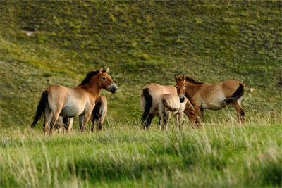
ecosystem around Hustai National Park. The one and only species of wild horse, the
Takhi which was discovered at the end of the 19th century is being reintroduced
to Mongolia in Hustai. MACNA, along with FRPH / Foundation Reserves Przewalski’s
Horses / brought a total number of 84 takhi to Mongolia during last 10years. Now
the number of takhi has reached more than 100. Terelj is situated 80 km northeast
of Ulaanbaatar, Terelj is famous for its unique granite rock formations and pristine
alpine scenery, and is a popular destination for tourists. The park lies at an altitude
of 1600meters.70 km east of Ulaanbaatar and in the Khan Khentii Protected Area.
This is the Motherland of Genghis Khan, contains numerous important historical and
cultural sites. National park created in 1993.
Three major river systems have their sources in the protected area; the Tuul River,
which flows into Russia’s Lake Baikal and continues to the Arctic Oceans, and the
Onon and Kherlen rivers, which flows east to join the Amur before emptying into
the Pacific Ocean. The mountain mass Gorkhi with high steeple-like peaks is covered
with forest on the northern slopes. This area is rich in the terms of wild life
Over 1.150 species of plants, characteristic of both taiga and steppe, have been
identified. Over 50 mammal species, 253 species of birds and species. The waterfall
is situated in the historically significant Orkhon Valley, whose river flows an
incredible 1120km to the North before it joins the mighty Selenge Gol. Also called
Ulaan Tsutgalan, the waterfall was formed by a unique combination of volcanic eruptions
and earthquakes about 20,000 years ago. The fall is naturally most impressive after
heavy rain. The waterfall is situated in the historically significant Orkhon Valley,
whose river flows an incredible 1120km to the North before it joins the mighty Selenge
Gol. Also called Ulaan Tsutgalan, the waterfall was formed by a unique combination
of volcanic eruptions and earthquakes about 20,000 years ago. The fall is naturally
most impressive after heavy rain. Chuluut River is a good size river.
It begins in Khangai Mountains and flows north for ~ 415km where it confluences
with Ider River and then both discharge their waters into the Selenge River. The
River flows through a sheer basalt canyon, which extends 100 kilometers from the
north of the Tuul River to the Atsat. The basalt is formed of lava of nearby extinct
volcanoes such as Khorgo Volcano and others. The River is rich in fish. Also it
is a National park. Chuluut River is a good size river. It begins in Khangai Mountains
and flows north for ~ 415km where it confluences with Ider River and then both discharge
their waters into the Selenge River. The River flows through a sheer basalt canyon,
which extends 100 kilometers from the north of the Tuul River to the Atsat. The
basalt is formed of lava of nearby extinct volcanoes such as Khorgo Volcano and
others. The River is rich in fish. Also it is a National park.
Orkhon water fall
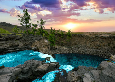 The waterfall is situated in the historically significant Orkhon Valley, whose river
flows an incredible 1120km to the North before it joins the mighty Selenge Gol.
Also called Ulaan Tsutgalan, the waterfall was formed by a unique combination of
volcanic eruptions and earthquakes about 20,000 years ago. The fall is naturally
most impressive after heavy rain.
The waterfall is situated in the historically significant Orkhon Valley, whose river
flows an incredible 1120km to the North before it joins the mighty Selenge Gol.
Also called Ulaan Tsutgalan, the waterfall was formed by a unique combination of
volcanic eruptions and earthquakes about 20,000 years ago. The fall is naturally
most impressive after heavy rain.
Chuluut River
Chuluut River is a good size river. It begins in Khangai Mountains and flows north
for ~ 415km where it confluences with Ider River and then both discharge their waters
into the Selenge River. The River flows through a sheer basalt canyon, which extends
100 kilometers from the north of the Tuul River to the Atsat. The basalt is formed
of lava of nearby extinct volcanoes such as Khorgo Volcano and others. The River
is rich in fish. Also it is a National park.
Orkhon River
Orkhon River is one of the largest in Mongolia. It begins in the Khangai Mountains
and flows north for ~1.124km until the Selenge River, where it empties its waters.
Along with waterfalls and many legends, Orkhon River is particularly known for its
reach and diverse fish population. Orkhon River has numerous species of fish, such
as Pike, Mirror Carp, Baikal Sturgeon, Taimen, Sig, River Perch, Siberian Umber,
Roach, Ide, Bull Ide, Golden Carp, Amur Catfish and Burbot.
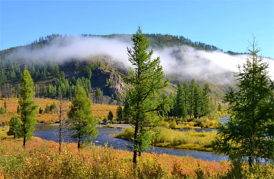
Terelj National Park
Khorgo Volcano
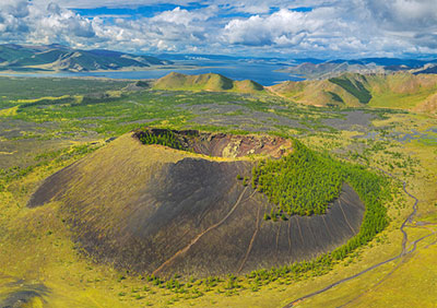 Khorgo-Terkhiin Tsagaan Nuur National park was established to protect the spectacular
mountain scenery and endangered species of fauna and flora. The area has extinct
volcanoes, many beautiful lakes, a great number of animals and birds, and is definitely
one of the best natural tourist attractions. Khorgo is a unique natural complex
(2240 m), National Park surrounded by the Khangai Mountains, which reach as 3000
meters above the sea level. In the craters some of them are very tiny crystal- clears
lakes. The Khorgo crater, situated at an altitude of 2.210 meters with a diameter
of 20 meters and depth of 70 to 80 meters, is the most interesting at all.
Khorgo-Terkhiin Tsagaan Nuur National park was established to protect the spectacular
mountain scenery and endangered species of fauna and flora. The area has extinct
volcanoes, many beautiful lakes, a great number of animals and birds, and is definitely
one of the best natural tourist attractions. Khorgo is a unique natural complex
(2240 m), National Park surrounded by the Khangai Mountains, which reach as 3000
meters above the sea level. In the craters some of them are very tiny crystal- clears
lakes. The Khorgo crater, situated at an altitude of 2.210 meters with a diameter
of 20 meters and depth of 70 to 80 meters, is the most interesting at all.
There is no lake in this crater, but clouds of steam jet out it is crevices forming
ice moulds in winter , which from a distance look like large flocks of sheep scattered
on the mountain. Near the crater there are dozens of small caverns with stalactites
hanging from their ceiling and walls. About 8000 years ago volcanic lava flooded
the valleys nearby which are covered today with small woods and a great variety
of berries and flowers. In the woods there are lots of deer, wild goat and other
animals, as well as various kinds of birds.
Ugii lake
Ugii Lake is 1.337 meters above the sea level in Ugii soum in Arkhangai province.
It covered 25 square kilometers, and is known for its reach bird and fish diversity.
The fish population is represented by pike, catfish, barscharten, which are the
most common types providing enough fish for industrial fishing. Fifty to eighty
tons are caught annually. Among the birds, it is not rare to spot at Swan Goose,
White Spoonbill and Dalmatian Pelican.
Khan Khentii Protected Area
 The Khan Khentii Strictly Protected Area is situated in the territory of Erdene
and Mungunmorit soums of Tuv aimag, Batshireet, Umnudelger soums of Khentii aimag,
and Eroo and Mandal soums of Selenge aimag. The area encompasses 1.227.074 hectares
of the rugged Khentii Mountains, stretching from just northeast of Ulaanbaatar to
the Russian border. It was included special protection in 1992 by Parliament Resolution
No 11. In 1995, it was included in the category strictly protected area by Parliament
Resolution No 26.Khan Khentii mountain range has preserved its original features
and is located between Eurasian coniferous forest taiga and Central Asian arid steppe.
The sources of three major river systems spring from the protected area. The Tuul
which flows to Russia’s lake Baikal and on to the Arctic Ocean, and the Onon and
Kherlen, which flow east to join Amur before emptying into Pacific Ocean.
The Khan Khentii Strictly Protected Area is situated in the territory of Erdene
and Mungunmorit soums of Tuv aimag, Batshireet, Umnudelger soums of Khentii aimag,
and Eroo and Mandal soums of Selenge aimag. The area encompasses 1.227.074 hectares
of the rugged Khentii Mountains, stretching from just northeast of Ulaanbaatar to
the Russian border. It was included special protection in 1992 by Parliament Resolution
No 11. In 1995, it was included in the category strictly protected area by Parliament
Resolution No 26.Khan Khentii mountain range has preserved its original features
and is located between Eurasian coniferous forest taiga and Central Asian arid steppe.
The sources of three major river systems spring from the protected area. The Tuul
which flows to Russia’s lake Baikal and on to the Arctic Ocean, and the Onon and
Kherlen, which flow east to join Amur before emptying into Pacific Ocean.
SOME OF OUR Partners